Tuesday 8 November 2011

04/11/2011 Beinn Narnain

Beinn Narnain 926

Length: 7.62 miles  12.26 km, Ascent: +944m, Naismith: 3h 48m

After almost 2 months commuting to Reading I finally set foot on a hill again.

quick day out to stretch the legs.

car to car in 4 hours

04/09/2011 Beinn Narnain

Beinn Narnain 926

Length: 7.62 miles  12.26 km, Ascent: +944m, Naismith: 3h 48m

quick day out to stretch the legs.

car to car in 4 hours

Monday 1 August 2011

30/07/2011 To Rotten Bottom and back again

Erie Hill (donald)
Garelet Dod (donald)
Cape Law (donald)
White Coomb (donald/corbett)
Lochcraig Head (donald)
Molls Cleugh Dod (donald)

Length: 13.7 miles  22.0 km, Ascent: +1301m, Naismith: 6h 35m

Another solo day so I took full advantage to indulge in my growing Donald habit.

welcome to scotland
Parked up at on the road at Talla Linnfoots farm. On with the boots and over the bridge and up Garelet Hill despite the dire warnings on the notice board. I can only imagine that this is a very old sign (pre outdoor access code) or is some throw back to the water board. It's a stiff wee pull to the top but ther views quickly open up. I was able to see Broad Law and the unmistakable mast.

With my ML training approaching I thought I would make the effort to estimate timing betwen hills, so out with the map despite the very good visibility, and some mental arithmetic followed. I was a bit smug when Erie Hill  arrived right on schedule after wading through calf deep woodrush. A pause for brunch and more mental arithmetic and then it was on to Garelet Dod. This time there was a quadbike track to follow. Now, either my sums were wrong or these parallel lines of flattened grass shaved 15 minutes off my estimated time. I suspect that it speeded things up, my counting isn't that bad.
molls cleugh dod from erie hill 

I had reached a point in my plan for the day where I could
  1. Drop down to the gameshope burn, cross by the footbridge marked on ther 25k map and then climb up to Molls Cleugh Dod, move on to Lochcraig Head and descend to Meggat Stone via Nickies Knowe and Wood Brae.
  2. Continue on to Cape Law, make for Rotten Bottom, Lochcraig Hill and return over Molls Cleugh Dod.
Plan 2 won. I was slightly concered because it looked very far. These hills lack distinct features. To differentiate between Bidean nam Bian and Buachaille Etive Mor is pretty straight forward. These Donalds hills are all big grassy lumps, regular map checking is really essential to keep track of progress. Subtle features are revealed as the walk continues, craggy cleughs, boggy lochans and occasional boggy bogs.
hill, probably din law
It still looked very far, even though the map said 1.5km to Cape Law it looked almost twice that distance. What was I flapping about? I had come out for a walk. I was a fit as a fit thing. 3 big bowls of pasta the night before. 6 Munros the previous week (4 of which had been a 12 hour session on the Grey Corries). I am confident in my navigation. (see previously mentioned 12 hour session in the Grey Corries). Sod it. Start walking.

Needless to say Cape Law arrived bang on time and gave me the first surprise of the day. Another walker. Anywhere else it would have been expected, but here, I was genuinely surprised. He was sitting with his doggy so I paused for a brief chat as I passed. He expressed the same level of surprise at seeing me.

rotten bottom. check the map if you don't believe me
The next feature was Rotten Bottom. This is never going to bode well wherever the circumstances. On the descent from Cape Law I could see a dog leg in the dyke so I cut across, aiming for the point where the dyke stopped. It stopped because Rottten Bottom started.

It wasn't as rottern as it could have been. We've not had much rain so I didn't encounter the really boggy bit until I was almost across. Double back and double back again until I worked my way around it. I knew it was over because the dyke started again.

The next bump was called Firthhope Rig and, as I had been obsessing over Donalds, I hadn't noticed how close it was to White Coomb (corbett). So, as I was passing, I strolled across and back again. Bonus Tick. You don't get many of them. Back on route to Lochcraig Head and then a short reascent to Molls Cleugh Dod.

loch skene from lochcraig hill. it feeds the gray mare's tail
I had discovered there was a bothy at Gameshope and I had decided to visit it. This led me down to where the 25k map shows a footbridge. No footbridge. I found a rough path along the east side of the burn and followed this easily to a big barn opposite the bothy. On the opposite side of the burn is a depth guage. I can only assume that the burn can get quite big - it does have quite a large catchment area. No such problems today, the bothy was reached easily and is very nice. No wood burning stove but then there isn't any wood around to burn. Gameshope's lower reaches are very pretty and would not be out of place in the Lakes. Fortunately, they are in Upper Tweedale and are much less visited.

vallet of ther gameshope. erie hill is the pointier one
Left the car at 10:15 returned at 17:30. 42 Donalds out of 89 - 47.19% but who's counting?

Monday 25 July 2011

22/07/2011 Beinn a'Bheithir

Sgorr Dhonuill (munro)
Sgorr Dhearg (munro)

A solo day and a mere 25 years it's taken to return to this particular hill. The first attempt was in winter, sometime in the mid to late '80s and I was with my Dad and one of his pals. There was a thaw on and lumps of snow were falling from the face of the summit so I decided not to finish the hill but wait while they bagged the summit and came back. “You were right, that was dodgy”. Vindication. I also lost my casio watch. Funny how things stick in your memory.

the dragon's tooth
classic pic
2 years ago, Mrs H, Cb and myself went to climb School House ridge. I was under the impression that it was a Grade I but it I've now read somewhere it is Grade II. Mostly a hill walk but a short steep section with considerable exposure and no rope defeated us.
towards mull and lismore island
Attempt no. 3 was last winter, 2 hours battling through the trees resulted in Cb and I emerging into the corrie in waist to almost chest deep powder snow. We had a quick conference and decided to try and find the path down. A further half an hour of floundering got us to the deer fence (about 100m) and some tracks that we followed back to the proper path and eventually the car. If, by some chance, we had actually managed to get to the bottom of the route and climb it, we would have come down into the corrie in the dark and struggled to find the route down.

looking east to glencoe


So, 4th time lucky. A bright sunny day. 2 hours from the car to the bealach, a bite to eat and the elusive peak was in the bag. The view was quite superb. Mull, Ardgour, Mamores, Ben Nevis, Glencoe, Bidean, Ben Starav and Cruachan. Just as well Mrs H hasn't done it. Worth a return visit.

Back at the car 5 ½ hours after starting.

Wednesday 20 July 2011

19/07/2011 Grey Corries

Stob Ban (munro) 
Stob Choire Claurigh (munro)
Stob Coire an Laoigh (munro) 
Sgurr Choinnich Mor (munro)


Length: 15.9 miles  25.7 km, Ascent: +1834m, Naismith: 8h 11m

This one has been on the todo list for a long time.

And so it came to pass that the weans were to be minded by the most excellent nanny and papa and H and Mrs H were to go to the hills again. You'd think we'd know better by now.


We had hatched a plan so cunning that you could pin a tail on it and call it a fox. Drop the kids off just before bed time get them settled and drive, drive, drive to a suitable place, sleep in our wonderful, ever reliable, magical estate car and then be placed perfectly for an early start and early return to previously mentioned kids.


The best laid plans etc. etc. etc. We made it to Fort William by midnight and, too tired to carry on, headed for the most excellent North Face car park. It wasn't a busy as I had expected. On the last visit there had been 2 motor homes taking up at least half a dozen spaces. I regarded this as "a bit cheeky". No such problems finding a space. 1 tent occupied by a group of silent MTB'ers with their bikes padlocked outside their tent was all that there was.


We got settled in to our bags, too tired, even for a cup of tea.


I was awoken by the rain. Then by some midges venturing in through the open window. Finally at about 6am, I heard the rumble of a diesel engine and poked my head slowly over the window ledge. A police car doing a slow drive by and then it was gone again. Time to get up.


We packed bags and drove to the road head for the Grey Corries. Here we were able to get the stove on for a breakfast cuppa, dressed in hill clothes, packed much food into sacs and we were off!

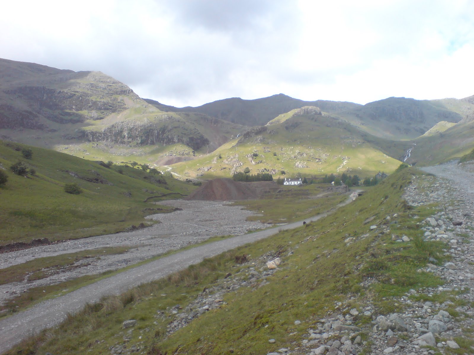
The route we (I) had opted for was to take in 4 peaks, to do this in a logical way, we would walk through the Lairig Leacach to the wee bothy and then climb Stob Ban by the stalkers path (only marked on 1:25000 map). From there it would the long haul up to Stob Choire Claurigh and the start of the Grey Corries ridge. We had a shower of rain on the way to the bothy but then it cleared and the Stob Ban section was dry and it looked promising. The cloud remained fixed on Stob Choire Claurigh. So we asended into the murk and were rewarded by 15 to 20m visibility.
big slabs

I'd love to post lots of photos of the gorgeous views but there was none. I'm sure it is beautiful. I cannot verify that. What I can do is be particularly smug about my navigation. Not only did we do the right hills in the right order, but we made it back to the car. Bonus.
Stob Ban

Our only adventure was on the top Stob Coire Easin. Here is a junction of sorts, this is the point in the ridge where, to turn right takes the walker down the ridge towards the dam and the car, to turn left takes the walker further away from the car, and civilisation into the depths of Lochaber and almost trackless wilderness. And bog.
Stob Ban in glorious panorama

After a quick conference, we felt all was ok, I took a bearing and we turned left to follow a faint track heading in roughly the right direction between great piles of stone. After descending for 5 mins I mentioned that I wasn't happy with the direction and ground we were covering. Mrs H agreed so we turned around and re climbed the hill only to find a better track heading in exactly the right direction. This led to further adventure.
halfaseesaw, wet

Mrs H had had a wee slip on the way across the bealach between Stob Ban and Stob Choire Claurigh. The rock is mostly quartz in nature and tends to form large flat sections which, in the rain, were slippy. This knocked her confidence and her hip and maybe her knee too.
after some rooting about on internet looks like a Dactylorhiza maculata, Heath Spotted-orchid

So, when the ridge became narrower, rockier, slippier and steeper, we became slower. Then the rain started. The next 2 hours were taken up by edging down big bocks of scree to reach the bealach, crossing to the last Munro and the seemingly endless succession of  false tops and apparently pursuing a phantom sheep that defecated on the path every 6 feet.  On one false top in particular, if the cloud had been any thicker, I could have quite easily turned around  thinking I'd bagged the summit. The plus side the endless ascent was followed by a remarkably rapid descent and re ascent of the top.
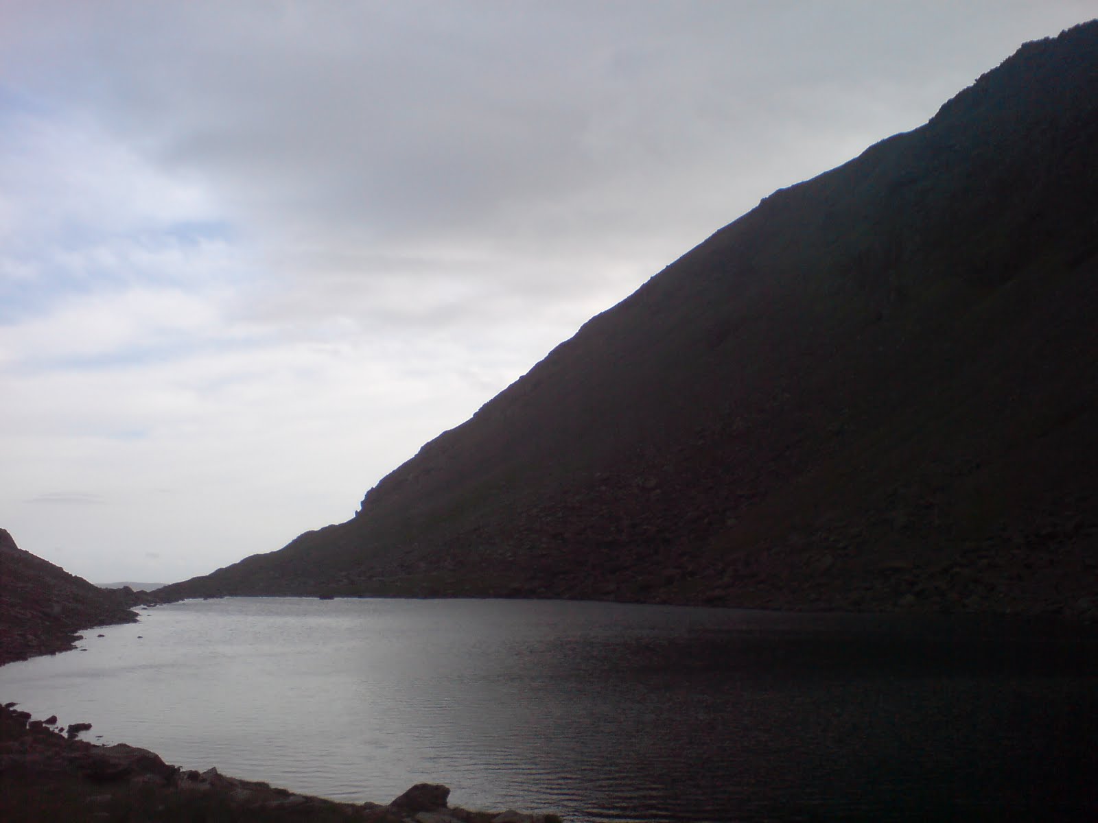
the dam


Happy to be heading back to civilisation, we started the long walk downhill. The guide book says to descent to the dam and cross the burn. This left a few questions lingering in my mind. Above or below the dam? How to get to the dam? How to get up the other side???? I worry about stuff like this.


This was solved by heading for the trees above the dam, hanging onto the deer fence and lowering ourselves down the steep bank (judging by the shape of the fence, I gather this is what everyone else has done too). I had considered sitting astride the dam and doing a bum shuffle across (I think the alpine mountaineering term for this is "à cheval"). This was instantly overruled by Mrs H. We opted for stepping across the burn and just getting wet(er). Climb up the opposite bank and over the style. This leads a to a concrete walkway and brings you to the track. All we were left with was a plod in the shelter of the forest.
puggy line bridge

I was delighted to see the wee railway bridge through a gap in the trees. If you can imagine the old trestle bridges popular in cowboy movies, well, this is a miniature version. Very cool. This line was built to run from the aluminium smelter in Fort William to Laggan for engineering purposes. The main one being drilling a tunnel from Laggan under the Grey Corries, the Aonachs and Ben Nevis.

Back at the car 12 hours after leaving for tea, painkillers and clean, dry clothes.

Home for midnight. So the plan was a partial success.

Wednesday 13 July 2011

12/07/2011 Ben Bheula

Ben Bheula (corbett)

Length: 8.73 miles  14.0 km Ascent: +1020m Naismith: 4h 31m

This was the third attempt at this Corbett. The first time me n' Mrs H didn't even get out the car. We couldn't open the door for the gale force wind. Attempt No. 2 ended in confusion, rain and a complete lack of motivation.

This time things would be different. Mrs H had said to go off myself, partly due to the previous days partial success and partly because I'm going have to work 5 days a week in a few weeks time. It may take some getting used to.

I was motivated, the weather was fine. What could possibly go wrong?

All started well, I followed the track up from Lettermay and continued up the new forestry path which brings you to steep grass at NS174988. I zigzagged up until the angle leveled off a wee bit and stopped for brunch. I knew that the way down from the summit was going to be interesting so I sat and studied the crags and came up with a solution.
Ben Bheula from NS176985


Satisfied with the way forward, I wandered up the ridge pausing only to swat flies, catch my breath or mop the sweat from my brow. Eventually arrived at the spot height 560 and took in the views.

To get to the Lochan na Cnaimh requires descent along the top of some small crags and a trend westwards. Fortunately it's not as high as it looks.

I reached the outflow of the lochan and was surprised to see a dam made from large rocks and a pipe with a sluice gate on the dry side.
Lochan na Cnaimh from the dam

I could see no sign of the path marked on the map that runs up to the bealach, so it was more steep grass and bog to reach the bealach where I managed to rip a large hole on the leg of my favourite trousers whilst climbing over the only fence of the day. Much bad language followed, fortunately I was on my own.

The next significant feature was the remains of a Grumman Wildcat (Martlet) F4F-3. The story can be found here.

I didn't see the cockpit remains or the engine. These two parts were about 10 to 15 meters apart.

wing section

and 
not sure


Looking up at Creag Sgoilte, I realised there was no direct route up so I'd have to move round to the west side. I eventually found and then followed a shallow gully and it brought me to a dip in the 2 summits of Creag Sgoilte. An easy wander along the summit ridge brought me to the summit proper and I found about 5 meters of faint path, the only hill path I'd seen all day.
at last, the summit in sight

I tried to remember the way down I'd made up in my head, unsurprisingly I couldn't match what I was standing on to what I'd seen before. The short gully I thought would take me down one "terrace" looked too steep so I wandered off towards the North-westish hoping to out flank the crags. I could see a path on the ridge below but couldn't see a way down.

I decided to take a look along a small grassy terrace and this proved more promising as I could see a grassy ramp leading to more level ground. Further round I found a straightforward if slightly steep way down and very soon I was on the path I'd seen from above. Not that it lasted long. From then on it was just a matter of picking my way down through bog and marsh to the slightly boggier and marshier Cowal Way to the nice dry firm road and back to the car.

I recon I took 6 hours give or take stoppage time. Felt more like 12.

11/07/2011 Ettrick forest

Bodesbeck Law (donald)
Capel Fell (donald)
Croft Head (donald)
Loch Fell (donald)
Wind Fell (donald) cancelled
Ettrick Pen (donald) cancelled

Length: 12.0 miles  19.3 km Ascent: +1201m Naismith: 5h 52m

Original plan was
Length: 13.3 miles  21.3 km Ascent: +1417m Naismith: 6h 38m

The weather forecast was for heavy thundey showers working their way south so a trip to the borders seemed like a good idea. I consulted my big book of things to do and Ettrick circuit looked good. (I hadn't noticed how far it was by road).


The drive down to Moffat was nice. Moffatdale was lovely and we eventually reached St. Mary's Loch then the Gordon Arms hotel. Turn right and drive some more. Follow signs for Ettrck and eventually arrive at the road end.

It had been my intention to go clockwise, but there was a tempting sign at the road end with "Ettrick Circuit" I took this to be a "sign". We started off up the first hill of the day, Bodesbeck Law. After about half a mile there is a small footbridge over the burn and it is signed Bodesbeck Law. After a quick map check we stuck with our original intention of following the forestry track onto the hills east ridge. This gave us an easy warm up to start.
me on Bodesbeck Law

The problem with doing the circuit this way is the distance between hill 1 and hill 2 is just under 3km. If you go clockwise the hills are closely spaced and the last hill can be skipped if legs are tired or time is pressing. We, or rather I, deprived us of that option by going anticlockwise.
Ettrick to Bodesbeck Farm path.

The ridge forms the regional boundary between Dumfries and Galloway and The Borders. The boundary is marked by a dry stane dyke which for 2 or 3 km is in perfect condition.
where do the stones come from? White Shank looking back toward Bodesbeck Law.


We strolled on along the undulating and occasionally boggy ground and eventually we came to hill no. 2 for the day, Capel Fell. 
big cloud aeroplane

We then descended to Ettrick Head and followed the Southern Upland Way to the bottom of Cat Shoulder on Croft Head. This section doesn't seem to get much traffic and I wouldn't fancy it in really bad weather or snow with a big pack! After a short T break we headed up and down Croft Head then tackled the steep climb up to Loch Fell (couldn't see a loch anywhere).
Hart Fell and Bog Cotton

Here is where plans had to be changed, Mrs H declared a sore leg and was in some discomfort so we skipped Wind Fell and Ettrick Pen and headed straight for Ettrick Head and the long slow hobble back to the car. We had a good nosey at the Over Phawhope bothy on the way past.

Back to the car about 7 hrs after we left it and munched jelly babies all the way home.

Friday 8 July 2011

14/11/2010 Flashback to last winter's only route!

Great Gully Buttress (a day oot in the 'Coe)

Me n' Cb went for a route on Sunday (14th), I wasn't sure what would be 'in' so I thought an easy snowed up buttress route would be the best bet. mmmm almost right. I've had a notion to do the big buttresses on the Buachaille for a while now and I thought that Great Gully Buttress would be fairly straight forward - we'd gone to do it as a scramble the week before but it was cloudy and wet and soggy - so we just did the 2 munros by the normal route instead. Scramble grade is 1 or 2 so I thought winter II at the most.

Anyway, things went well. There are 3 rock bands each progressively harder. We roped up early at the first and easiest rock band to sort out heads/gear. We hadn't climbed anything since July and I felt a bit rusty. After that the rope went back into the bag until middle rock band which was a bit more serious looking. I led the first so, ever the gentleman, allowed Cb to take the lead (her first winter lead) No problems there. We led through for a couple of easy pitches. Close to the top I led a long traverse out to the right, up a gully where I got some solidish turf then traversed back to the left – I ran out almost all the rope, got a couple of bomber runners but probably only gained 25 meters !! Cb led through again and then by some bizarre coincidence it was the crux and my lead. The scrambles book says something like “climb the rack band by a diagonal crack running left to right then work back left to the top of the buttress”. The slab was covered in thin ice (melting) and unconsolidated snow, I had a bomber no. 8 hex in so I climbed a little above that and got a good crack to get my axe into. After that there was nothing to be found. I must have swept almost all the snow from the slab searching for a gear/axe/foot placement. I could see how it could be skipped up in the summer on dry rock.

I retreated back to my last runner and attempted to thrash my way up what remained of the gully Cb was belayed in but again I couldn't find any suitable cracks and we took the decision to back off, I must have been 5m from the top of the buttress.

How annoying.

It was about 15:30 by this point; sunset was 16:30, neither of us fancied down climbing the whole ridge. I took a look at Narrow Gully between Great Gully and Broad Buttresses and thought that we could ab into it. Looking down on it looked OK to downclimb. There was a massive pointy rock to use as an anchor. Cb went first and I followed. When I tried to pull the rope down it was stuck. Fortunately it wasn't vertical so I was able to quickly climb back up on the ropes and clear some snow. Ab'd again to halfway and threaded a rock with a sling and a crab, pulled the rope and rigged a new abb. however, when we actually got into the gully, it was Shit. The sensible option was to climb up to the top of the gully and continue from there on known ground. That worked out well. I packed up the rope and we started the slightly tedious climb up. We stopped for a breather and juice at the top of the gully where the buttress ended and I enjoyed standing on a bit of flat ground for 5 mins.

Daylight was fading but the rest of the route was just a hill walk so the rope stayed in the bag, and I stared breaking trail along the bottom of Great Gully Upper Face. That face shrinks in height so when it disappears, double back and that brings you in a zig zag to the top of Broad Buttress. Fantastic sunset view so I let Cb break trail for 5 mins so I could get a breather and call the wife to say we were still on the hill.

I caught up with Cb and took over the lead. There is a small bump in the ridge about 3 meters high - couldn't go round it so over the top was only option. I cleared large quantities of snow from the first half so find a delightful little ledge that I could step up to - cleared more snow to find a crack that took the axe and a foot hold. That was that dealt with. Rather than climb up to the ridge we contoured round to meet the normal route. - Cb was getting pretty tired. We made the top of the corrie path at sunset. Time for 3 chocolate biscuits, a handful of M n M's and tidy up harness and rack. (that's all I ate all day). The descent took about 2 hrs - mostly because the bottom of the path (where it runs above a big drop) was covered in a thin sheet of ice. It was probably the scariest bit of the day. Most of it was done a la derrière.

All in all it was good fun even if we didn't get a tick!! Handled the retreat without stress. We were on the hill for about 8 hours and didn’t see a soul for most of that. The norries would have been crawling with bodies.

Lessons learned:
  1. Remember where you've put both of your big belay mitts.
  2. Take the winter rope and not the summer one because it's furry - attracts snow and acts like a sponge and hasn’t been dry/Teflon treated. On the plus side it didn't freeze because it wasn't cold enough.
  3. Take a bit longer to rig an abseil - had to leave a sling and crab coz I couldn't be arsed raking about in my sac for tat. Probably would have saved time in the long run if I’d used tat in the first place.
  4. Conditions can vary the grade by (in my limited experience) grade and a half. I reckon it would have gone at II if it was in condition, the last 7 or 8 meters being the III maybe overall II/III would be more accurate. Last year we climbed The Slant which is Grade I. I felt it to be about grade II ½ at the time. Cb hated it and cursed me all the way to the top. I had great fun.


04/07/2011 Glencoe and utter failure

Climbed out of bed and that was about the biggest success of the day.

To explain, we had just returned from a short family holiday to London to visit relatives and generally get out the house. Anyway, one thing led to another and my youngest child became infected with whatever that girl in the Exorcist had. I'm sure he produced more than his own body weight. Mrs H and I believed we had avoided it but no, it was not pretty but he's all better now and back to mischief.

The forecast was good so I thought, "I'm feeling better, go bag a hill". I've had a notion to do Bidean nam Bian from Stob Coire nam Beith for a while following an unsuccessful winter climbing expedition to No. 4 buttress. (450 meters of Grade II, I'll be back)

The drive up was pleasant in the beautiful sunshine. I managed a few sneaky peeks at the scene of previous adventures on BEM. NE buttress still looks steep!!!

From the almost deserted car park near the Clachaig turn off, I toiled up the path sweating and feeling sick, stopping every couple of minutes until the feeling passed, then pressing on again. 50% of me wished I'd stopped for food at the Green Welly 50% was glad I hadn't. The original plan had been Dinnertime Buttress and on to SCnL, Bidean, SCnB and back to the car. Normally that would be a reasonable day out. I think I was a wee bit over ambitious.....

Reality set in,The Plan got ditched, and I thought I just go up and take a look at the cliffs on SCnB.

Didn't even manage that.

Stob Coire nam Beith looks mighty impressive as you approach through a small gorge. I could pick out Deep Cut chimney, No. 4 buttress and Summit Gully but I had no stamina, felt weak and thought, "no, go home". so I did.

And the final kick in the stanes - MLT has been cancelled again!

You win some, you lose some.

Wednesday 6 July 2011

18/06/2011 Langdale

Pike o' Blisco 2304" (wainwright/hewitt)
Cold Pike 2259" (wainwright/hewitt)
Crinkle Crags South Top 834m (hewitt)
Crinkle Crags (Long Top) 859m (wainwright/hewitt)
Shelter Crags 815 (hewitt)

Length: 8.81 miles  14.2 km, Ascent: +1079m, Naismith: 4h 38m


Somewhere new again. After about 3 hours drive (including a short and unintentional detour to Shap), We parked up at a small layby near Rosset Bridge. Geared up and off we went in the direction of Stool End (snigger). From there we took the left branch path into Oxendale and over the footbridge up, up, up towards Red Tarn. Just before Red Tarn, a path swings left to reach the summit of Pike o' Blisco and the view was worth the wait. Scafell was still hidden behind Crinkle Crags but we could see across to Coniston and north to Helvellyn. We didn't stop for long and it was back down to the pass and up to the rocky summit of Cold Pike.

Crinkle Crags from Cold Pike

From here the path to Crinkle Crags is a wee bit obvious. And tedious. But we got there in the end.

Pleasant scrambly walking takes you up and over the south top and from there you can see the infamous "bad step". This is the reason I opted to do this walk clockwise. This bad step can be avoided completely by following the obvious path to the left (west) We went for it in true hard core pepsi-max stylee. 2 moves later and it was all over. We even had an audience.

Brown fleeced sheep - if you can see them.


I had intended to do a complete circuit of Langdale from Pike o' Blisco, over Bow Fell and finishing on Harrison Stickle but it was hot and we were slow. So after much looking at watches, thinking up excuses and general faffing we continued along the ridge to the Three Tarns and from there we descended The Band back to Stool End (snigger).

Pike of Stickle is the prominent peak on the left, Loft crag is the large buttress on the right.
Excellent views from The Band across to Pike of Stickle and Loft Crags.

Looking down into Langdale from The Band.


It was probably the slightly convoluted start but it seemed to take ages to get anywhere despite moving steadily. I've checked the distances and our Coniston walk was 13 miles and at Langdale we covered 8 miles. It just felt that we weren't making progress all day, probably because we could see the car for most of the walk so didn't get that remote sensation that I feel is a big part of the experience. In contrast, the Coniston walk felt longer than 13. My feet thought it felt at least 18 and they are pretty good at this sort of thing.

Wednesday 15 June 2011

11/06/2011 The Buachaille, Part 3 Curved Ridge

An okayish forecast meant climbing was on. I had been browsing through the SMC Glencoe and the Scrambles in Lochaber guides for easy multi pitch mountain routes and had come up with a couple of options.

  • 'D' Gully buttress on Buachaille Etive Mor (Diff/Severe)
  • No. 3 Buttress on Stob Corie Nam Beith (Grade 3 Scramble)
  • No. 1 Buttress on Stob Corie Nam Beith (grade 3S Scramble)

D Gully buttress was graded Difficult/Severe with the crux (Hell's Wall) graded at Severe and unprotected. However the guide also noted that this is avoidable to the left and right. With a shortish walk in Cb and I decided that this would be the preferable option. Increasing the appeal was the possibility of finishing the buttress and then linking Curved Ridge into a cracking mountain day.

Forecast was for warm with light winds but a risk of heavy, slow moving showers with a risk of lightening.

We left the car in warm sunshine and blue sky, by the time we reached the waterslab black clouds had moved in over the hill and a few spots of rain had fallen. We deliberated and decided to make a decision at the bottom of the climb. We pressed on up the crappy scree which was causing me some discomfort and were passed by a couple of guys that I took to be MRT of some sort. We passed a pair who turned out to be from Prestwick and had a chat.

At the bottom of the route the black clouds had not shifted and I was concerned that we might get half way up and get drenched (or worse) in a sudden downpour. We were unanimous in leaving the route for another day but not wanting to head home without a tick, we decided to take the rope and rack for a walk up Curved Ridge.

By the time we got to the start of the scramble to the base of Curved Ridge, my ankles were in agony from walking up the scree and the weight on my back. A tea break request was denied and so we pushed on until we found a reasonable sized ledge (about 1m wide) to sit on. The ledge was off to the left of the ridge and below was steep - as near vertical that it made no difference - it was here I started having a wee "moment" the pain in my ankles and weight of the pack were sowing the seeds of doubt in my head - I was getting a bit scared, there, I've said it. I realised I would have to stand up on the ledge and swing my pack onto my shoulder to start climbing. It didn't make me feel better. I drank but didn't feel like eating (this did not go unnoticed apparently).

As pleasant as it was to sit in the sun, the pain in my ankles had gone and it was time to move on up. The thought of down climbing just wasn't an option, it was far, far easier to continue. I regained my feet and after a few tentative steps regained my composure (for the time being) and we climbed on enjoying the good holds and grippy rock.

The ridge is almost in two parts, the first initial climb from the start of Easy Gully then there is a short walk. The second section is steeper with a buttress of sorts on the left, a gully/crack then a buttress on the right. The sensible option is the left buttress, climb a series of steps till you are standing at the bottom of a short, smooth wall with a crack on it's left side. You know you're on the right path because the rock is clean, smooth, polished and covered in crampon scratches. The exposure here is not massive but enough to freak me a little - I put it down to carrying as heavy pack. Cb had climbed a rib just to the right and I shuffled along a ledge to see if it would go. I didn't fancy it so I shuffled back to the smooth polished wall. It was at this point our new pals from Prestwick climbed past, the younger taking Cb's route and the, well I'll be honest, older (65 apparently) taking the route I was looking at. I had mentioned to Cb about getting the rope out. She thought I was kidding!! Fortunately I was shown exactly how to climb the wall by my more experienced fellow scrambler. I was impressed by the smoothness and ease with which he moved up. Shamed into action I followed without the style, grace or economy of movement. I found the "thank god" hold and I was up. Hurrah. What had I been worried about?

I hadn't suffered any of this self doubt/exposure fear on our previous week's trip up the North Buttress. Climbing is such a head game. I'm sure if I had been on steeper ground and roped up I would have been quite delighted. In winter I have been more exposed with worse holds. Over the past few years we've done a few routes together and Tower Ridge seems to have become the benchmark by which I measure a routes difficulty. Everything we've done since seems to be harder. Maybe I'm just getting older.

The rest of the ridge was delightful and we reached the cairn to find the two MRT guys having a tea break. I thought that was a good idea so I had a drink but still not eating - it was at this point Cb said she knew something was wrong 'coz I wasn't eating. I'm so transparent sometimes.

Cb had insisted on doing Crowberry Tower but I'd done it many years before and had finally managed to get over the post traumatic stress. My dad had been in charge of navigating and when we reached the top of CR he read the next paragraph without reading on.... I got a bit of a fright when I realised we were on the Tower. I vaguely remember the down climb and relief at getting back to the top of CR. We had come up from the top of Crowberry Ridge and was unaware of the easy climb from Crowberry Tower Gap. Parents!

As we were sitting, our new pals moved past and I asked if they were going up CT?, "yes", "Could you take my friend up with you?", "Sure, no problem". So glad about that.....

I moved of round to the left of the crag and took what is probably the worst way to the summit, and managed to get a photo of the 3 on top of the Tower.

Cb downclimbed and soon appeared above the gap. not much else to do but start the slog down hill.

We arrived at the car at about 15:00 5 hours after starting so we must have moved at a reasonable pace.

Wednesday 8 June 2011

06/06/2011 The Buachailles, Part 2 The wee Buachaille

A wee hillwalk with Mrs H and a pal up Buachaille Etive Beag. It started off wet but the weather improved as the day went - sun and superb views down to Loch Etive.
Southern Top
Looking South down Glen Etive


05/06/2011 The Buachailles, Part 1 North Buttress (West Route)

According to the guide book, this is the original summer line up the buttress and the second route on the Buachaille.

Finally! Weather OK. This one has been on the "to-do" list for a couple of years so following the path from the car park across the foot of the hill we eventually ended up at the burn that flows down Great Gully. From here we headed for two large boulders that sit on a small shoulder and mark the point where the route starts. They are an easily recognisable landmark so even we couldn't go wrong.

The guidebook grades it as Moderate/Grade 3(s) scramble (s for serious, I think). If you follow the fault line up the centre of the buttress then it goes at about Difficult.

Climbingbuddy (Cb) was in Spain climbing hardstuff recently and I hadn't climbed anything properly since November. However, Cb injured her arm/shoulder and her ankle wasn't too clever either. This was starting to have the makings of a really good old school EPIC.

on the way up

We donned harnesses at the boulders and made our way up the crappy scree to the foot of the route proper. Then Cb stumbled and tweaked her shoulder. Quick conference - 2 options
  1. Turn back before it all goes horribly wrong.
  2. Press on in Captain Scott style but take the easier option of Moderate.

Option 2 it was.

The first pitch looked OK so Cb went first - any problems get some gear in and I'd lower her off. Things went well so the first pitch was cut short to 30 meters. I led through and on another 30 meters to where the break out right option is available. I set up a belay and Cb came up confident that things were now OK. Cb's pitch and it was a detour out to the right and up about 10m then work back left to regain the bottom of a right slanting line.

Cb in the chimney line about to break right

After standing for what seemed a rather long time the radio crackled and said (I summarise and paraphrase)- "boulder come off", "bit of a fright", "havin a fag", "gie's a minute".

I waited.

Eventually, I got the good news and climbed up to the next belay to find

blood!!!!!!!

Cb on her 2nd? 3rd? fag but just a flesh wound.

bad rock


I was able to establish through the tears and snotters that Cb had tied onto a seemingly solid rock and then that rock detatched itself without warning from the mountain. Must have been a wee bit of a fright then. The rock had fallen onto the sling wrapped round it and very nearly severed it. Good job it missed the rope eh?

looking down

From that point on we both became a bit paranoid as every big rock seems suspect but in truth only a couple were dodgy.

I led the next pitch and immediately committed a schoolboy error. I placed 2 solid runners and then moved left creating rope drag and restricting myself so much that I had to belay halfway up the next pitch and ask Cb if she could lead through coz I is stoopid.

I enjoyed the view while an adult did some proper climbing.

looking across the Devil's staircase to the Mamores
The angle had eased off and I suspected we were nearing the top of the route, I stayed attached to the rope and walked round to the right for a look then moved back left. I had reached what I have now learned is the "High ledge" so the climbing was over. Radio'd Cb to come up and we packed the gear away but left harnesses on just in case.

The next bit of the ridge was just a scamble, ironically on the best rock we'd had yet, dry, solid and lots of friction. A wee while later and we were on the summit - no one else in sight.

Apologies for the poor photos, the camera on my phone is crap. A good day out.

31/04/2011 Coniston circuit (shameless peak bagging)

Wetherlam (wainwright/hewitt)
Black Sail (hewitt)
Swirl How (wainwright/hewitt)
Great Carrs (wainwright)
Grey Friar (wainwright/hewitt)
Brim Fell (wainwright)
Coniston Old Man (wainwright/hewitt)
Dow Crag (wainwright/hewitt)

Length: 13.2 miles  21.2 km, Ascent: +1479m, Naismith: 6h 42m

Well, the MLT training has been postponed. Not enough people to run the course. I had to consol myself with the thought that Mrs H and me might go to Rum with some friends and do the Rum Cuillin traverse, however other commitments and poor weather meant that this did not happen, I'm quite glad the MLT was postponed, we had a very wild week with a couple of big trees down on the estate and very heavy showers.

Just as events conspire against hill days, sometimes events work in favour, the forecast showed an improvement and Mrs H and I were up at 6 am and headed for Coniston. Neither of us had been before so we didn't know the main road A593 from Ambleside to Coniston is effectively single track for much of the way - this didn't seem to put off the odd HGV. It took a bit longer than expected to get to the village so we didn't leave the car till nearly 12.

sky
The route is straight forward, from Coniston follow the track past the miners bridge until a right fork takes you up above a row of cottages, a couple of switch backs and up to Hole Rake. A faint path (looks like a sheep track) branches off and takes you up (eventually) to Wetherlam. We were very slow up this section which is easy going on short grass. Our excuse is that we hadn't been out for a couple of weeks.

miners bridge
looking up Levers Water Beck
A pause for coffe and sandwiches. We could see most of the Cumbrian hills, Scafell and Scafell Pike (which semed to have attracted low cloud), Langdale and across to Helvellyn and Fairfield. To the South East was Grizedale Forest and the sea. A big lump lurked on the shore which I later discovered was http://en.wikipedia.org/wiki/Heysham_nuclear_power_station Off down across Black sail and down to the busy Swirl Hause. Prison Band to the summit of Swirl How was pleasant, very easy rocks and out of the cold wind and in the sun too.

that way to Swirl How
on Prison Band
From the summit we could see the remaining tops and although I expected a minor mutiny, Mrs H was happy to bag a few Wainrights so we started with Great Carrs. On the way, I came across a memorial at NY270008 http://www.yorkshire-aircraft.co.uk/aircraft/ll505.html 8 crew. All died. Average age 22. The remains of the undercarriage sit next to the cairn. The rest of the aircraft was pushed over into Broad Slack to prevent it being reported as an accident again.

Brim Fell (L) and Dow Crag (R) from Kidson How
We climbed Grey Friar before contouring round on a small path to Brim Fell and Coniston. Hiding behind the massive summit cairn at the top of the Old Man, we scoffed snickers and coffee. The wind seemed to be getting stronger, we heard some of the stones on the cairn moving in the wind, so we packed up and headed to Goat's Hawse and back into the sun. From there we had a really good view of the crags on Dow Crag - I've checked for routes and there's a few in my ability level of Moderate to Difficult - even a couple of easy winter routes although I'm not sure how often they would be in condition... It might be worth a day out at some point.

Low water from Coniston Old Man

Dow Crag isn't as big or a steep as it looks so in 45 minutes from the Old Man summit we were up and back down to Goat Hawse. I had originally planned on continuing over Brown Pike but we were keen to get back to the car so back down past Goat Water and The cove to meet Walna Scar Road and down to Coniston. As it turned out Brown Pike would have taken another 10 mins and may have been a nicer descent.

Goat Water

Back to the car and home for 11pm. I think we took about 8 hours in total. Thanks to Mrs. H for the photos. I was sore the next day!!

Wednesday 4 May 2011

29/04/2011 Broad Law

Cramalt Craig (Donald)
Broad Law (Corbett/Donald)
Talla Cleuch Head (Donald)

Length: 13.0 miles  21.0 km, Ascent: +980m, Naismith: 5h 50m

I was at a loose end after my climbing buddy called off our proposed climbing day. Mrs halfaseesaw said I should just go out and get fitter for my upcoming MLT week. So I decided that a quick trip to another new hill was in order.

An earlier start meant I got out to the M74 in better time than the day before and if I hadn’t missed my junction I would have got there even quicker. The drive up Moffatdale is lovely even if you have to play dodge the pot hole at the start. First left after Tibbie Shiels Inn and you soon see Meggat Dam (the largest earth dam in Scotland) follow the road a wee bit further and there is a view point at Cramalt. I parked here with the intention of following the old Thief’s Road out to Dollar Law. 

 Top of the new track. Looking east to Fifescar Knowe from Dun Law

I made excellent time up the track which now runs all the way to the top of the ridge (1hour). Bits of the old road/track can be seen occasionally and I had to get the map and compass out to find out which lump was the one I wanted. Compass set for Cramalt Craig, I walked along the grassy ridge (I’m sure it would be doable on a MTB) in the wind which was getting stronger all the time. Rain had been forecast for around Cheviot but I thought I was well away from that and so was travelling light – warm mid layer and windproof top.

Broad Fell from Middle Hill

Distances are deceiving and Broad Law looked a long way away but I was soon climbing steadily to reach the radio mast on the summit and then walked along to take shelter out of the wind behind a dyke to sort out the next leg. There was a wee Donald to grab before heading back to the car - Talla Cleuch Head.

Looking southish from shepherds cairn on Cairn Law

Down to Cairn Law and turn right for a short climb to the smallest summit cairn I’ve ever seen.

Broad Law from Talla Cleuch Head cairn

Cutting back across the hill from the col I saw some people ascending – a path! My planned descent across the peat hags was abandoned in favour of a little used track which took me directly to the Megget Stone at 430m  the highest point on the road and only 8 meters lower than Drumochter Pass. A few spots of rain quickly turned into a heavy shower made more uncomfortable by the gale blowing into my face. I had to keep my shades on to keep the rain out of my eyes. A number of cars passed but none offered a lift but to be fair I didn’t have my thumb out. At one point the wind and rain were driving into my front while I could feel the sun on my neck and see my shadow on the wet road.
A long 5km in an hour brought me back to the car in  a total time of 6hrs and I'd dried out by then.